People in Texas and all across the country, have been following the development, approach and aftermath of Hurricane Harvey. Information leading to making the forecasts and warnings on the hurricane came from space, the skies, the ocean and the ground.
This is the realm of meteorologists and climate scientists and their assortment of technological instruments and computer algorithms. The data allows them to determine how big a storm may get, where it will go, how hard the winds will blow and how much rainfall we can expect.
The big NWS failure of 2005 and 2012
But, let’s get back to the ECMWF and their very accurate hurricane prediction model. Many readers may have noticed over the past few years that when news services run updates on hurricane tracking, the “U.K. model” is always included, and sometimes, it shows a different track for a hurricane than the data put out by NOAA’s National Hurricane Center (NHC).

In 2005, the NWS failed to forecast Katrina’s direct hit on New Orleans, Louisiana, until two days out. Then, in 2012, the NWS computer models failed to predict Hurricane Sandy’s turn into New Jersey, whereas the ECMWF was spot on. The track of Sandy resulted in a worse case scenario for storm surge for coastal regions from New Jersey north to Connecticut including New York City and Long Island.
The one good thing to come out of the “infamous” faux pas was that Congress in 2013 poured $48 million into NWS weather modeling. This produced two innovations, one from NASA and the other from the National Oceanic and Atmospheric Administration (NOAA).
Both of the new technologies were tested on Hurricane Harvey, alongside the U.K.’s ECMWF model. On Thursday, a day prior to landfall, the experiment agreed with the European model that Harvey would plow inland, stall, then head back out over the Gulf of Mexico before making a second landfall near Houston, Texas.
NOAA’s brand-new forecasting model
Two years ago, NOAA’s Geophysical Fluid Dynamics Laboratory (GFDL) in Princeton, New Jersey, won a competition to provide a computer code for next-generation weather modeling at the NWS. Before being tried on Harvey, older computer models had to wait on the results of a time-consuming simulation of global weather patterns before zooming onto a particular area.

Only then could a high-resolution model for hurricanes be run. With GDFL’s new code, a simulation can be run along with the global weather simulation. In theory, says Science Magazine, this should lead to “improving forecasts for hurricane paths because its fine-scaled predictions feed immediately into the model’s next run, rather than lagging behind.”
The GFDL model is called FV3. It also correctly predicted that Harvey would have a double eye wall (the second band of storms encircling the band of storms enclosing the eye). The FV3 model also has a zoom-in view, and this allowed for the prediction of the extreme rainfall totals seen by Houston some five days in advance, says Shian-Jiann Lin, the GFDL scientist who led the development FV3 model.
What Lin has done is to put meteorologists and climate scientists on the same page in forecasting and predicting extreme weather events. Meteorologists want to get a forecast out as quick as possible, getting as many data as possible from satellites, balloons and buoys to make their report.

Climate scientists, on the other hand, focus on the physics of the weather, using computer modeling to produce what they hope are plausible simulations of weather events that can go back decades or more. But now the two groups are working together in making “sub-seasonal to seasonal” predictions that can reach into the future from a month to two years.
With Lin’s new code, the FV3 was run at a one-kilometer resolution, and as Lin promised, the violent walls of a hurricane’s eye opened in his code. The FV3 model divides the atmosphere into boxes and simulates conditions in each one. To avoid problems at the poles, its coordinates are based on a cubed sphere. The program can also nest grids to simulate weather at different scales.
For those who may be interested in how the system works, go to the FVGFS Product Viewer. While the system is still in the experimental stage, you can factor in a date, location and the type of weather-related information you want, producing an image.

NASA’s contribution to hurricane forecasting
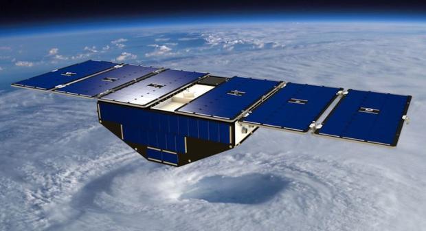
The intensity of a hurricane can be hard to predict because data on wind speeds is sometimes spotty and sometimes difficult to collect. However, NASA has come to the rescue with the launch on December 16, 2016, of a constellation of eight identical microsatellites, called the Cyclone Global Navigation Satellite System (CYGNSS).
CYGNSS works by detecting the surface roughness of the ocean, a proxy for wind speed, from the reflected radio signals of GPS satellites. This method is used because sea surface roughness corresponds to wind speed. The science behind CYGNSS is to understand the correlation between ocean surface properties, moist atmospheric thermodynamics, radiation, and convective dynamics in the inner core of a tropical cyclone.
The ability of the CYGNSS constellation to track the development of surface winds in a major storm is demonstrated by preliminary measurements made during its flyover of Tropical Cyclone Enawo on March 6, 2017, as the system approached Madagascar with surface winds in excess of 100 mph.
At that time, four of the eight satellites were operating in the science mode because four were still being made ready for commissioning, but with Harvey, all of them were operational. This now effectively doubles the coverage of hurricanes and other weather events around the world.